Nature of Cartography
August 16, 2011 § Leave a comment
Maps are ubiquitous. All cultures have used maps in one way or another.
In class, we covered various historic maps, ranging from road networks (Tabula Peutingeriana, modern metros – Harry Beck’s London Tube), Mappamundi, incorporating religion (Psalter Map), and political and state maps (Cabot Map, Carte de France).
Historically, traditional maps were topological rather than strictly geographical.  Significant mapping examples include:
- John Snow’s 1854 – Broad Street Pump
- Charles Minard’s 1861 map of Napoleon’s Russian Campaign.
- Charles Booth’s 1890-1903 Poverty Mapping
- (Sydney) Country of Cumberland Plan – 1856
- Burch & Cheswick’s 1999 – Internet Map
Maps are selective representations of reality. With selective representations of:
- Scale
- Projection
- Orientation
- Symbolisation
- Key
- Colour
- Title
- Caption
- {Date}
- (Publication)
Class Activity
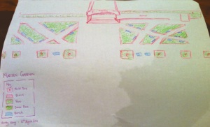
We did a quick sketch of the area in front of Madsen Entrance. Making sure we included attributes above. Essentially elements I had initially missed in my sketch (Key, Title, Date ) were added in later. Certain ones have been omitted for various due to uncertainty or redundancy (scale, projection, caption).
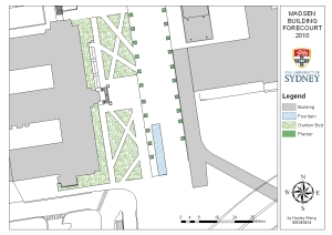
This analogue activity was followed by it’s digital equivalent using ArcGIS, for 2007 and 2010 views of the Madsen Forecourt.


Leave a comment